Earth Observation Services
Continuous improvements in processing algorithms allow to capture and understand the risks associated with soil movement in various mine regimes using historical data from radar satellites.
Optical remote sensing
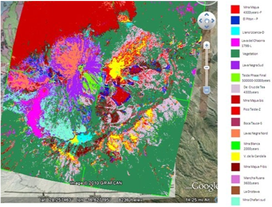
We provide tailored services and information products for geomorphological, structural and lithologic investigations, using optical remote sensing data, from satellite and airborne (manned and unmanned) platforms.
 Benefits
Land use, vegetation state, volcano monitoring and mining tailing dams pollution.
Customers
Farmers, agricultural industry and forestry, mining companies.
Technology
We use radar and optical panchromatic, multispectral/hyperspectral, and thermal sensor data from various platforms to classify and isolate lithologic units and their structural and geomorphological settings and parameters. The analysis accuracy can be improved by using spectral signatures from local geological samples, and we provide also spectra measuring services for the VNIR and TIR. We also carry out detailed photo-interpretation for geomorphological and structural mapping, providing a wealth of information without the need to set foot on the ground, as: relative age of landforms and lithologic units, fault kinematics and age, stratimetry, etc.
Ground displacement measurements by InSAR and real time GPS analysis
We provide tailored services and information products for the monitoring of the ground motions and for the generation of models and scenarios, aiding in the deformation source analysis. Depending on application, required precision and site extent and location, we provide a comprehensive portfolio of ground deformation monitoring products and services, ranging from very local optical leveling surveys, to local/regional Continuous GPS network data analysis, to high resolution ground displacement maps obtained from satellite radar missions. We use state of the art geodetic and remote sensing analysis methods.
 In particular:
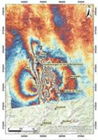
- Co-seismic ground deformation map. It is a map showing at each location the amount of ground motion (in cm) due to a moderate to large earthquake.
- Inter-seismic ground deformation map. It is a map showing the yearly rate of ground motion (ground velocity, in mm/yr) occurred within a specified time period. For each measurement point the time series of the ground displacement is also provided.
- Land subsidence map. It is a map showing the yearly rate of ground lowering (in mm/yr) generally due to fluid withdrawal from the subsoil. For each measurement point the time series of the ground displacement is also provided. The high resolution versions of this product are also used to monitor sinkholes, mining-induced ground deformation, cave collapses, and other local phenomena.
- Active landslide map. It is a map showing for a landslide-prone area the yearly rate of ground motion (in mm/yr) due to gravitational slope movements. For each measurement point the time series of the ground displacement is also provided
Benefits
Infrastructures safety, investigate and monitor geohazards over wide areas, assess the temporal evolution of a single, at risk, location. Land use, vegetation state, volcano monitoring and mining tailing dams pollution.
Customers
Cultural heritage institutions, regional and local agencies, transport and power supply companies.
Technology
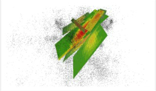
InSAR is an instrument adopted in geodesy and remote sensing. This geodetic methodology uses two or more SAR (Synthetic Aperture Radar) images to generate surface deformation charts, and digital elevation models, considering the differences in the phase from the returning waves to the active sensor on satellite or aircraft.
 Continuous improvements in processing algorithms allow to capture and understand the risks associated with soil movement in various mine regimes. Historical or archived data from radar satellites are valuable in providing an understanding and evaluating the behavioral characteristics of any TSF.
Radar satellite data, such as that provided by the new Sentinel-1 (from ESA Copernicus Programme), both operating in the C-Band, allow the study of historical terrain deformation and direct monitoring thanks to the short revisiting time. Historical terrain deformation is essential to establish an accurate baseline for more focused and advanced monitoring or monitoring of the first signs of soil movement.
Progressive monitoring plays a vital role in the better understanding of the natural behavior of mining dams. To this goal, InSAR is a powerful tool for monitoring large areas, such as the total number of homes in the mine and adjacent areas and land. The InSAR analysis can accurately detect and measure the movement of the surface, which indicates the potential occurrence of geotechnical risks.
The high spatial density of the InSAR measurements is a valuable input to restrict the geomechanical models, which allows us to better understand the measured surface displacement.